The RMS has responded to the questions we asked as follows.
 Question 1) How is Roads and Maritime planning to monitor air quality pre, during and post construction? If not, why not? How and when will this information be available?
Answer:
Before, during and post-construction, air quality monitoring is managed by Sydney Motorway Corporation and its delivery contractors, CPB, Dragados and Samsung (CDS), in line with planning conditions.
The conditions of approval for the New M5, show operational air quality monitoring and reporting requirements (refer to conditions E1-E31).
Air quality measurements are taken at “receptors”, which were identified as part of the EIS. A map and list of these can be found in the attached document.
Our comment:
Conditions E1-E31 are here: e1-e31. They include:
(c) two ground level receptors near the St Peters ventilation outlet, at locations suitable for detecting any impact on air quality from the outlet;
(d) one location within the vicinity of the St Peters lnterchange, as a location suitable for detecting any impact on air quality within the surrounding residential receptors;
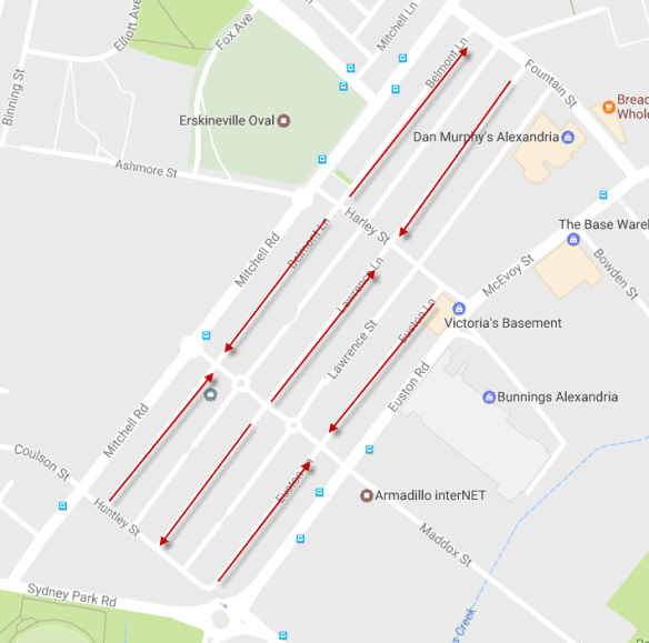
The word ‘receptor’ means pollution detector. None of these receptors are in Alexandria. None of these receptors will detect pollution from the tunnel exits or from traffic on Euston Road. None of these receptors will detect pollution from the stacks except when the wind is blowing in exactly the right (or wrong) direction.
Question 2) How is Roads and Maritime planning to monitor noise pre, during and post construction? If not, why not? How and when will this information be available?
Answer:
During construction, noise monitoring is managed by Sydney Motorway Corporation and its delivery contractors CDS.
The conditions of approval, show operational noise monitoring, reporting and display requirements (refer to planning conditions E32-E39).
Our comment:
Conditions E32-E39 are here: e2-e39. To summarise, RMS must have the objective of not exceeding the noise requirements of the NSW Road Noise Policy (DECCW, 2011), NSW Industrial Noise Polcy (EPA, 2000) and the Sleep Disturbance Application Note to the NSW Industrial Noise Policy, and the vibration goals for human exposure for existing ‘receivers’ (people), as presented in Assessing vibration: a technical guideline (DECC, 2006), “where feasible and reasonable”. Monitoring against expectations must be done, within a year of the Tollway opening.
The conditions are going to require RMS to sound-proof impacted homes, but there is little that can be done about vibration. Residents will no longer be able to open windows, and will be completely reliant on air-conditioning, which adds its own noise and vibration.
Question 3) Has a detailed traffic study been conducted which models the impact of WestConnex New M5 traffic flow on secondary roads in the local area? If not, when? How and when will this information be available?
Answer:
Outcomes of traffic modelling for the New M5 are contained within the New M5 Environmental Impact Statement (EIS), which is available to view online. In line with the planning conditions, Roads and Maritime carries out and displays the outcome of traffic counting both within 12 months and five years after completion, to assess the network’s performance.
Our comment:
We have searched the New M5 EIS and cannot find any traffic modelling of secondary roads in our area. We will follow up with RMS.
Question 4) Once WestConnex New M5 is operational, what traffic volumes are projected for the following streets: Euston St/McEvoy Road; Mitchell Road; Fountain Street; Henderson Road; Wyndham Street?
Answer:
Outcomes of traffic modelling for the New M5 are contained within the New M5 EIS which is available to view online. In line with EIS conditions, Roads and Maritime conducts and displays the outcome of traffic counting both within 12 months and five years after completion, to assess the network’s performance.
Our comment:
We have searched the New M5 EIS and cannot find any traffic modelling of secondary roads in our area. There is limited information available in the RMS Response to Submissions, which we have examined, and find unsatisfactory. We will follow up with RMS.
Question 5)  What does Roads and Maritime modelling show for AM/PM peak hour performance at key intersections, e.g.: Fountain Street and Mitchell Road; Fountain Street and Euston Road/McEvoy Street; Mitchell and Sydney Park Roads; Mitchell Road and Copeland Street; Mitchell Road and Henderson Road; Henderson Road and Wyndham Street?
Answer:
Outcomes of traffic modelling for New M5 are contained within the New M5 Environmental Impact Statement, which is available to view online. In line with EIS conditions, Roads and Maritime conducts and displays the outcome of traffic counting both within 12 months and within 5 years after completion, to assess the network’s performance.
Our comment:
We have searched the New M5 EIS and cannot find any traffic modelling of secondary roads in our area. There is limited information available in the RMS Response to Submissions, which we have examined, and find unsatisfactory. We will follow up with RMS.
Question 6) Has the CBA’s imminent move into ATP (bringing an extra 10,000 workers into the area) been factored in to the local traffic forecasts?
Answer
Roads and Maritime traffic modelling, and in collaboration with Transport for New South Wales’ broader transport masterplan for Sydney, takes into consideration population growth in the area and along the entire WestConnex corridor. Roads and Maritime forecasts are based on population projections from the Department of Planning and Environment (DP&E) available at:
http://www.planning.nsw.gov.au/Research-and-Demography/Demography/Population projections
The DP&E projections are at a Local Government Area (LGA) level. These projections are then refined at a smaller geographic level known as a Travel Zone by Transport Performance and Analytics (TPA), a specialist unit within Transport for NSW.
The TPA projections take into account the best information that is available at the time. A specific development may or may not be included, especially depending on the size of the development.
DP&E will generally update their projections every 2-3 years. TPA may release additional projections.
Our comment:
The Population Projections only include residential forecasts, and do not include workers, such as at the ATP. As noted by the RMS above, the reports would have been 2 to 3 years out of date when the RMS consulted them, which was now several years ago. We will be asking the RMS to address these issues.
Question 7) Do the forecasts factor in currently planned developments? e.g.: Ashmore Estate, Central to Eveleigh, Green Square, Waterloo Estate?
Answer:
Roads and Maritime traffic modelling, and in collaboration with Transport for New South Wales’ broader transport masterplan for Sydney, takes into consideration population growth in the area and along the entire WestConnex corridor. See response to question six for further information into how Roads and Maritime works with the DP&E.
Our comment:
As above, .it appears that RMS have confirmed that they are relying on estimates that were several year out of date at the time and that they have not accounted for major developments that have been announced since, and that they have only considered population growth, and not growth in the local workforce.
Question 8) Will the introduction of a ‘No Right hand turn’ at Mitchell Rd, as discussed in the EIS, be going ahead? If this is yet to be determined, when will a decision be made?
Answer:
Roads and Maritime is working with City of Sydney Council to finalise the traffic movements at key intersections within the scope of WestConnex New M5.
Our comment:
City of Sydney tell us that there has been no significant communications from RMS on these matters.
Question 9) How does the WestConnex Road Transport Model differ from Strategic Travel Model?
Answer:
The Sydney Strategic Travel Model (STM) includes all modes of travel; train, bus, vehicle driver, vehicle passenger, walk, bicycle and taxi.
The WestConnex Road Traffic Model (WRTM) incorporates the vehicle driver forecasts from the STM and has more sophisticated modelling of the routes which vehicles use especially the toll choice component.
Our comment:
Consultation with friendly traffic experts suggests that the main difference between WRTM and STM is that WRTM assumes a higher willingness to pay tolls. If so, then this raises the question of whether traffic forecasts may be too high. Lower than forecast traffic might reduce the impact on our area, which we would welcome. But we should also be mindful that lower than forecast patronage will increase the already high cost to the state, which we should not welcome.
Question 10)  The WRTM assumes a city-bound exit at Camperdown. Given that this is no longer happening, how does this impact forecasts?
Answer:
The proposed Camperdown on/off ramps were part of WestConnex M4-M5 Link, or “Stage 3” of the project. Its EIS, due mid-2017, will detail any traffic impacts on selected local roads around the St Peters Interchange (and other tunnel portals).
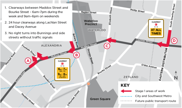
Question 11) What will be the speed limit on Euston Road?
Answer:
60km/h – between the New M5 motorway exit at the corner of Euston Road and Campbell Road and the intersection of Euston Road and Maddox Street.
PDF available here: RMS_responses_to_questions_raised_by_Alexandria_Residents_Action_Group-May_11-1.pdf

 We’re now waiting to see if the developer comes back with something more modest, or if they go to the Land and Environment Court.
 We have launched a new community campaign to get the Alexandria we want. It is crucial that at this point in time we make our voices heard. For more information, please visit: